Season’s greetings to you all, whatever your pursuits, beliefs, religion, practices and traditions are at this time of year! What is pretty common no matter what, is the obsession with the turn of the calendar year.
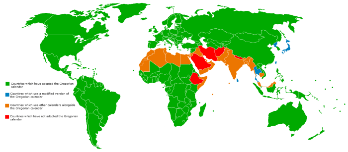
The Gregorian calendar is almost used universally across the globe. It is an adjustment to the Julian calendar in order to better fit with the Earth’s solar cycle, and so uses the 12 latin-based named months of January to December.
So almost everywhere in the world, this is the time of year of nostalgia and reflection, based on the flip of a calendar.
So, what do you go for? A review of the year’s newsworthy events? Box-office hit films? Sporting moments? Celebrity deaths (seriously)? Readers in the UK can check out this from the BBC and take their pick. In addition to shuffling through our social media feeds and looking at our personal year-in-review, it’s all very much media orientated. So let me offer you an alternative:
NASA Astronaut Photography: CEO Top Picks of 2017
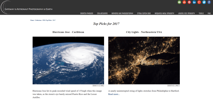
This simple but awe-inspiring web-page contains some of the most amazing images taken by astronauts over the past calendar year. If you have any love and interest for our lonely planet, you could easily spend an hour or two looking at this web-page as the images that it hosts can be downloaded at huge resolutions. This allows you to really look at the finer detail in them. Some of the images have more detailed information attached to them. Here are some of my favourites, and perhaps ideas for the classroom:

NASA’s ‘Earth at Night’ or ‘Earth Lights’ series of constructed images have become pretty iconic and a dream resource for most teachers. Hi-res images allow detailed exploration of settlement patterns, transport infrastructure and levels of development among other things. Taking Paris towards the bottom-left or London middle-top for example, you can see the splotchy shape of urban-sprawl, which has engulfed the smaller round splotched settlements around them. The patterns of lights allow us to see visually what is meant by a ‘conurbation’ which may not be so obvious on a map or visual satellite image. The strings of light that stretch like spiders legs map out settlements along the major transport routes away from those cities. NASA’s Earth Observatory just released this blog entry yesterday about changing lights. Worth a look!

Working at NOAA ESRL has given me a renewed appreciation for our atmosphere, particularly how thin the lower-part of it is. This beautiful image of a sun-rise highlights this perfectly. The diffused light from the sun spreads out with red, orange and yellow hues, abruptly ending showing where those light-refracting gases, the majority of the gases in our atmosphere, reside. What I equally love about this image is the silhouette of the convective cloud tops.

Europe’s most active volcano produces some excellent images from the ground and from above. You can look for clues that it is not devoid of human activity by looking for roads (see far left) that lead up to and around around the summit. If you have a keen eye you can look for evidence of old lava flows (admittedly tricky when the mountain is snow-covered!). The direction the smoke, steam and ash travels away from the crater gives you the local wind direction, in this case a north-westerly. Pairing this information with a regional map or atlas discussions can be had about which places may have to prepare for possible impacts from the eruption.
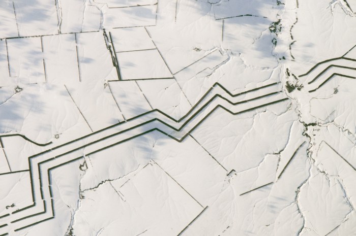
This image gives you clues of an economic activity that you would struggle to guess that takes place here. But despite the deep snow and lack of vegetation, these lines are actually evidence of farming. The thick zig-zagging lines are ‘shelter-belts’ or wind-breaks planted to protect crops and reduce the erosion of steppe soils by wind. The thinner lines are field boundaries marked by trees.
Which images from the NASA CEO picks of 2017 web-page are your favourites? What else could be learned and discovered from them?
Here are some more alternative look-backs at 2017. Have a gander and enjoy turning your ahead away from what’s controlled by the mass media just for a few minutes…
- 10 Breakthrough Technologies of 2017 – MIT Technology Review
- World Records Set in 2017 – MSN
- Best ‘out-of-this-world’ space stories of 2017 – Mother Nature Network
Finally, how about maybe playing a game with friends and family coming up with your own quirky lists like ‘a review of the best oops moments’ or ‘moments that made you feel most proud/happy etc…’ or ‘some of the silliest things <insert family member’s/friend’s name here> said/texted’? Revisit those memories, whether happy, sad, bittersweet…
Happy New Year to you all! I’ll be back in 2018!
