Before I start, all my education work via the Geogramblings’ “Life Geographic” blog is done all in my spare time, at my own cost but is free for you to access and enjoy. Usually here I mention how you can support my work; on this occasion, please instead consider contributing in some way to fundraising efforts to help those impacted by the Bridger Foothills Fire. Details are in both the video and the article below. Thank you! ❤️
A massive thank you to all members of the Bridger Canyon and Bozeman community who gave their permission for me to use their posts, images and videos. Some of these people have been deeply impacted by the wildfire. If you are a media or news outlet, please respect this and do not assume that any individual has given permission to further dissemination. If you wish to use or reference any part of the video or this blog post, I would be very happy to assist you. Please get in touch via https://www.geogramblings.com/contact.
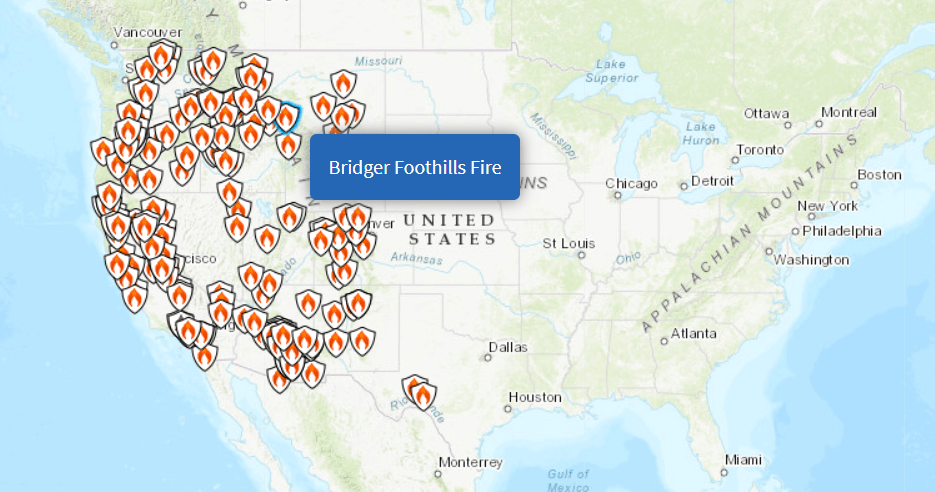
I have friends and family members in California and Colorado who are sharing fascinating but disturbing news and pictures with me. For example, deep orange skies in the San Francisco Bay Area thanks to smoke from multiple nearby wildfires, which are some of many wildfires taking place right now in the western United States. So why am I focusing on the Bridger Foothills Fire, which ignited just outside of Bozeman, Montana a few days ago?
Personal context: My connection to the Bozeman area
I have a deep emotional connection to the Bridger Canyon area and the town of Bozeman. My wife is American and her family on her dad’s side have a three-generation connection to the Bozeman area. In Bridger Canyon, the family have a house that was once the main occupance of my wife’s paternal grandparents but now is the place where the extended family comes together as often as we can.
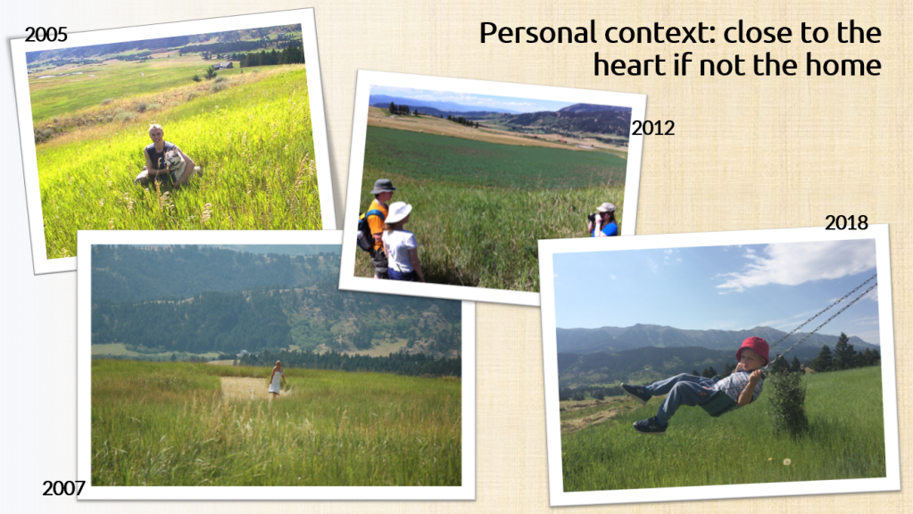
2005 was the first time I got to visit Montana and spend time at the house in Bridger Canyon. I fell so much in love with both my partner and the area that we decided to get married at the house in 2007. The picture above is a wonderful image of my mum wondering the fields outside the house on the day of the wedding, with the Bridger foothills in the background. While we lived in the UK, we got out to Bozeman as often as we could. In 2012 I was exceptionally thankful and lucky for the family to allow me to host a group of high-school students that I taught (here’s a video of some of the trip). The last time my wife and I got out there was in 2018; now we had two kids, and the picture shows my eldest on the house’s swingset with the Bridgers in the background. We haven’t been back since due to current circumstances.
I fondly recall the above to demonstrate that my connection is deep and emotive. But while this is so, it is important to acknowledge that my connection pales in comparison to that of my wife, her family and of course those whom Bridger Canyon is their home and everything twenty-four-seven, whether they have been there for months, years or generations. Later on in this article I link to a heartbreaking but beautiful and hopeful piece written by someone who had lost their home.
Location & Situation
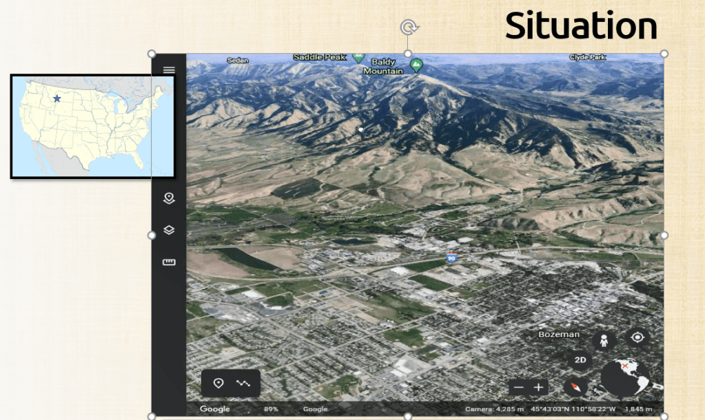
The Bridger mountain range is located just to the north-east of the town of Bozeman, Montana. In tourist terms, Bozeman is considered one of the ‘gateway’ towns to Yellowstone National Park to the south-east. (It’s about a 2 hour drive, but by western US standards that’s more or less ‘down the road’!). The Google Earth image below looks north-east towards the southern end of the Bridger range. On the tip of the range, about halfway up is the ‘College M’ – that is significant and I’ll come back to that later.
Fires are a result of arid conditions, but particularly drought, which is defined as a prolonged period of time in which an area experiences less than normal precipitation (e.g. rainfall). When temperatures are high, then evapotranspiration (which takes moisture out of the ground and vegetation) is greater than precipitation. The climate of the Bozeman area means it is susceptable to drought conditions.
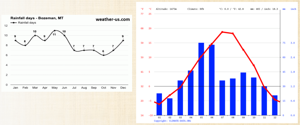
Temperatures in the summer average around 68*F (20*C), but individual days in the 80’s are not uncommon. Coupled with low precipation rates in the summer (between 30-45mm/1.2-1.8in per month), then the pre-conditions for drought are set. Even slightly abnormal higher temperatures, and/or lower precipitation rates are problematic. When this aridity takes place, grasses and forests dry out, making it easier for them to ignite and burn – whether by natural causes such as a lightning strike or by careless human actions.
Over at https://www.drought.gov you can dive into a very comprensive, data- and spatially-rich analysis of drought conditions in the USA. You can search for any location in the States using a zip code or place name. Typing in ‘Bozeman’ brings up the current drought situation for Montana.
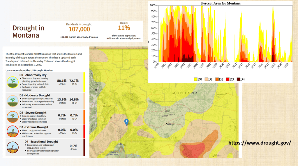
The map shows that most of Montana, 72.7%, is currently experiencing drought conditions. Bozeman and the area to it’s west is in ‘moderate drought’ where crop damage and water shortages are problems. The Bridger mountains and it’s canyon adjacent to Bozeman’s east is ‘abnormally dry’ where water deficits mean crop growth is impacted and voluntary water restrictions are in place.
Historically, the past two years in Montana have been relatively ‘mild’ in terms of drought, as indicated by the graph showing drought intensities between 2000 and 2020. The 2000s were a terrible time of drought for Montana, and I remember my family and I being dreadfully concerned ahead of the wedding in the summer of 2007, both regarding potential fire outbreaks but whether we would have enough water to host visiting family let alone a ceremony and reception – given that the first half of that decade had been so dry.
So there is a constant fire risk particularly in the months of July, August and September. Dotted all around fire-risk areas not just in Montana but elsewhere is ‘Smokey the Bear’. The picture below is taken from an article on the history of Smokey, but there is a display almost identical to this right by the road leading to the trailhead of the ‘College M’ hike.
:max_bytes(150000):strip_icc()/1090088428_b10f6afef3_o-58f16c865f9b582c4d1e9adb.jpg)
Guided by the US Department of Agriculture’s (USDA) Forest Service (see here for a GIS map of fire risk in Montana), Smokey will let people know whether the risk of wildfire in an area is low, moderate, high, very high or extreme.
How the fire spread
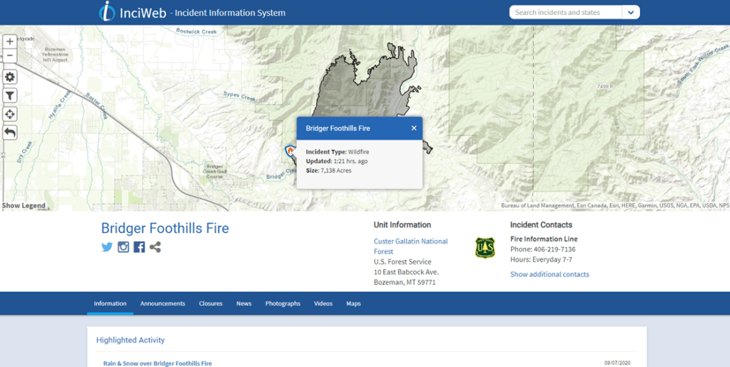
The InciWeb incident report stated:
“The Bridger Foothills Fire started about 3:00 pm on Friday, September 4, 2020 approximately 2.5 miles northeast of Bozeman, Montana. The cause is under investigation. Initial attack forces from local fire departments, US Forest Service and cooperators responded immediately, but were unsuccessful in halting the fire given the extreme dry conditions. By Friday night the fire had grown to about 400 acres.”
Just a few hours after ignition, this image was captured by Bozeman resident Laurel Koller.
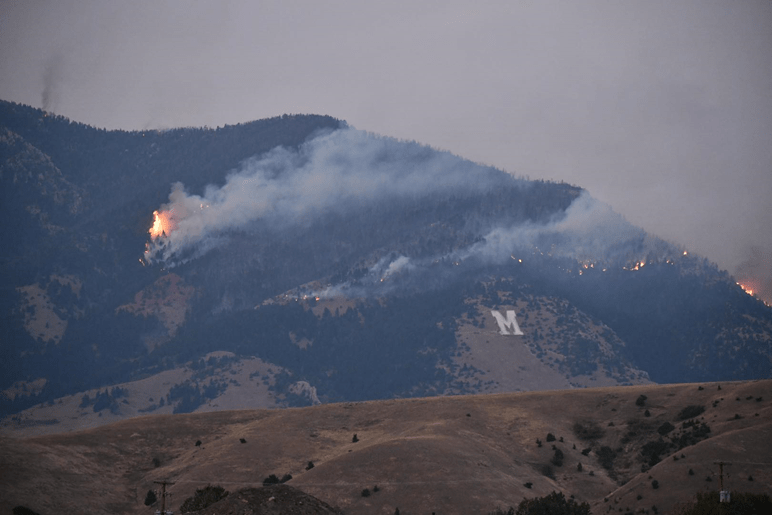
Laurel told me that she watched the fire progress, and one of the early responses she observed was the authorities dump water and fire retardant downslope of the fire. My educated guess is that this was to prevent the spread of the fire down towards and westwards towards the outskirts of Bozeman itself, which is more-or-less a few kilometers ‘towards you’ in the picture. But with strong westerly winds and gusts, the fire instead spread eastwards and up the towards the ridge.
This night-time timelapse below taken by Mikeal Béland shows the fire burning on the eastern side of the ridge.
The fire then expanded rapidly on the eastern side, pushing eastwards and northwards, growing from around 400 acres to 7000 acres over the course of Saturday 5th. This incredible timelapse shows that just in the space of thirty minutes, between 1:30pm and 2:00pm, how the fire rampantly marched northwards. Pause the video and compare the size and position of the smoke plume at the beginning and end of the video.
Winds and temperatures dropped slightly on Sunday, but by the end of Monday a cold front brought very welcome respite in the form of rain and sleet, and at higher altitudes, snow. The map below shows an OPS map of the fire in the early hours of Tuesday morning (7th).

Note the red boundary used for the edge of the burnt area. This particular symbol is used where the fire boundary is not contained. Since the whole boundary uses that type of red line, 0% of the fire was contained at that time.
Rob Maher, a professor at Montana State University in Bozeman, used the geospatial data publicly available via the National Interagency Fire Centre (NIFC) and overlayed it onto Google Earth. He produced this excellent video to give you a virual, layered flyover, giving you a great sense of scale and impact. This is what approximately 7000 acres of burnt land looks like.
Let’s return to the NIFC OPS Topo map, and point out a few things of interest. But before I do, I’ll give the disclaimer that my analysis of the map is educated guesswork. I have very little expertise on the mechinics of how wildfires spread, so I’m extrapolating from the knowledge and expertise I do have. I would very much welcome any commentary from those in-the-know!
What I found particularly fascinating were the physical (natural) and human features of the landscape that acted as fire breaks. Firstly, you have the crest of the ridge itself, forming the western boundary of the burn area. The wind carried the fire across the eastern side of the range, as it was blowing westward and ‘spilling’ over the crest and downslope into Bridger Canyon. What also probably helped is the fact that the crest is fairly steep and bald of vegetation, so they was little to burn. But I think it was the wind direction that mostly helped the crest form a fire break.
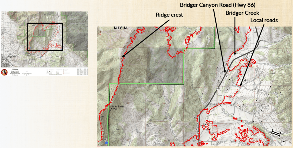
Staying with the physical landscape, I noticed that Bridger Creek an it’s flood plain also acted as a fire break, perhaps more due to the fact that in most places, as you come down into the valley off the range and the foothills, the tree density of trees opening up to larger areas of grass and cultatived land.
The roads acted as a fire break too. For the most part, the main highway (Bridger Canyon Road/Highway 86) which is the size of a large single-carriageway as we would recognise in the UK, held the fire back on it’s west side. However, with the strong wind gusts early on in the spread, the fire was able to ‘jump’ in a number of places. The secondary line of defense in terms of roads are the local access roads to people’s properties. For example, marked on the map above is a very clear line running along the local road of Tepee Ridge Road. This is a gravel road that is about 10 meters wide. Along with the land being mostly treeless, it proved to be a very effective fire break.
On the OPS map, properties such as houses, outbuildings, barns, stables etc are represented as black dots. It is saddening to see many of those inside the burnt area. The latest update stated that 28 homes were lost – more on the impacts later.
Below is an image from drone footage I took in 2018. The map shows the location of the drone marked as ‘X’, with the arrow pointing the way the drone was facing (west towards the Bridgers).
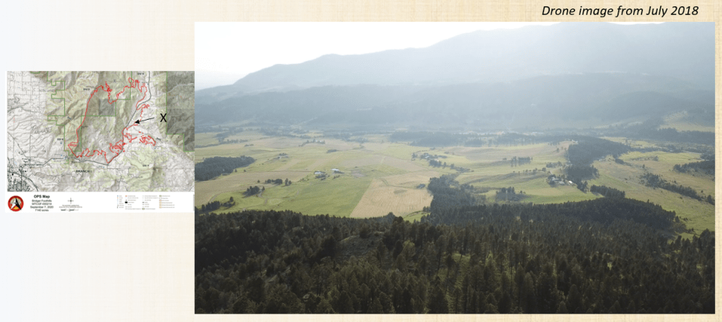
Now here is some footage taken by neighbours of ours. You can clearly see the dark, burnt areas of the valley side, being the Bridgers and the foothills, but the area immediately in front of the camera has been spared (so far) by the various landscape features mentioned acting as fire breaks.
Residents know all too well about the fire risk. Although it is not clear to see in the video above, land-owners will cultivate or manage their land to keep the grasses and vegetation as short as possible, reducing the fuel available for a fire to spread quickly and making it easier to manage. We have someone mow the grass at the start of summer, bail it up and take it away to be used as hay feed. We then take a lawn-mower to the grass directly around the house and create a buffer.
Then on Tuesday 8th, came a very welcome change in the weather. A cold front caused temperatures to plummet from the 80’s down to the 30’s (32*F is 0*C), and with it came rain and at the higher altitudes, snow. This was the view from Kelly Canyon, pretty much the southern end of Bridger Caynon, looking north up the valley. Rain rain, glorious rain.
This precipitation stunted the fire, only allowing a growth of 100 or so more acres of parched land. More importantly, it opened a window for the authorities and fire crews to make gains with containment efforts. Nevertheless, the authorities still were issuing cautions, warnings and reminders.
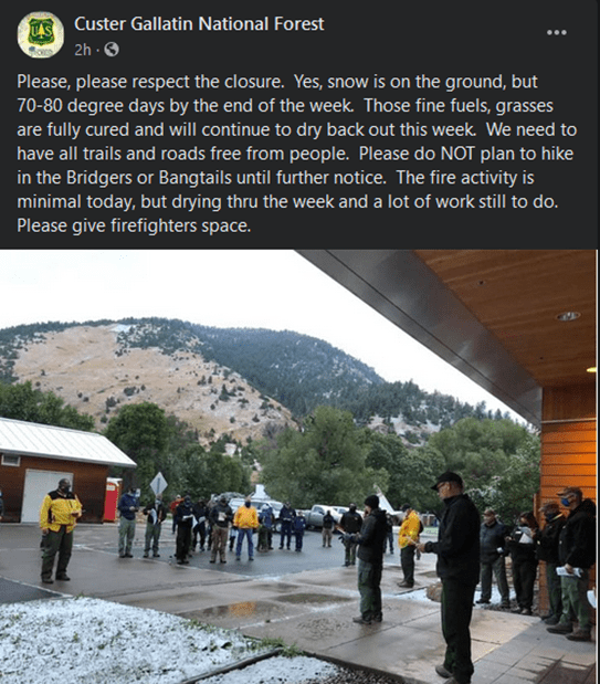
Yes, the snow and rain has helped, but with vegetation being ‘fully cured’ (i.e. being so dried out that it is unable to retain or absorb a significant amount of moisture) due to prior high temperatures and low precipitation rates, then as soon as the dry warm weather returns, then it all becomes easily combustable again. In other words, one spell of rain or snow will not stop the spread of the fire without intervention and containment efforts.
Impacts
As mentioned earlier, at the time of composing this article, 28 homes had been lost to the fire. Land has been burned, and people and livestock had been evacuated.
Despite the devastation being felt by those who have lost homes or property, some have been generous enough to share pictures or video of how they have been impacted. Below are some which I was given permission to share here.
Paul Osincup owns a house in the foothills just off Bridger Canyon Road. His first tweet shows a very concerning picture of a blaze a little too close for comfort to his house.
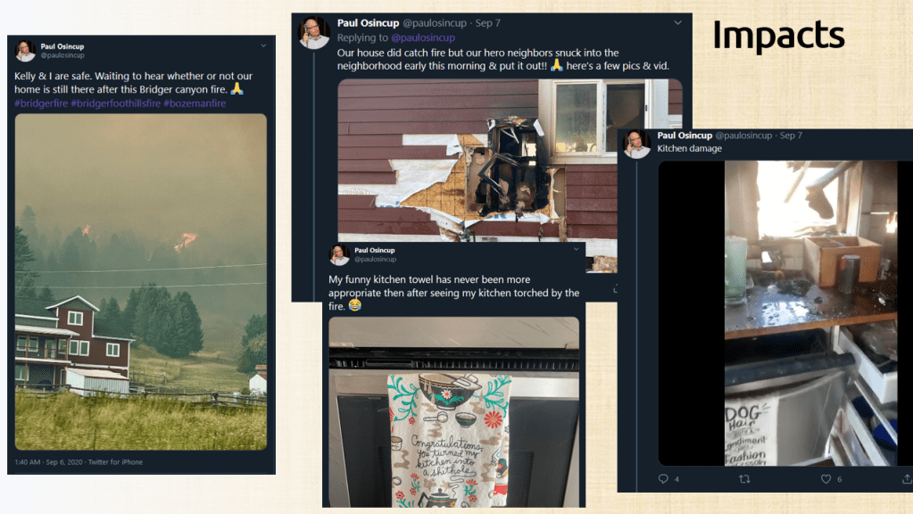
Unfortunately, Paul and Kelly’s house did catch fire. But fortunately, they were lucky that neighbours were on hand to put it out as it was burning through to the kitchen. Left unchecked, it probably would have meant the loss of their home, or at least enough damage to make the place uninhabitable.
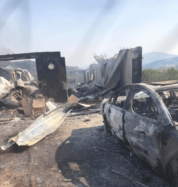
Loana Arguero-Abuto shared this sad footage of her home and one other home that had burnt down.
Blaise Lapinski’s family have a home in the Canyon. Currently his son’s family have been living there for several years, but the picture shows that the fire left very little to be recovered.
The fire also caused a power outage, as reported by NorthWestern Energy.
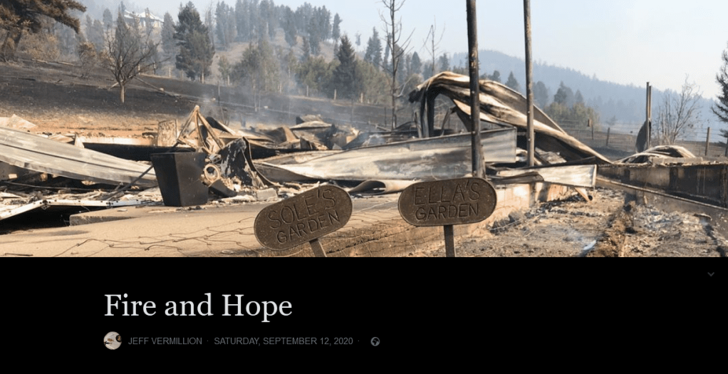
Jeff Vermillion, a resident of Bridger Caynon, penned and shared heartbreaking but beautiful and hopeful piece of writing over on Facebook. His family has seen their house in Bridger Caynon destroyed three times in three years, with this fire being “almost exactly to the year after finally moving back in” since the breaking of an ice dam forced them out. Jeff titled his piece “Fire and Hope”, the ‘fire’ being analogous to everything else going on (coronavirus, polarising politics etc) as well as literal. While the whole piece is an astonishing read, one particular paragraph paints a picture of the whirlwind of emotions, and gives a message to all those who have lost something:
Thankfully though, after a lot of reflection, I’ve determined my wife and I can’t blame ourselves, and nor can any of you impacted by this fire, for what we packed or what we did not. We did our best, and wildfire tends to sort out your priorities real quickly. By that I mean in an instant—well before it registers in your brain days later— you somehow instinctively realize that the things you need from your home are exactly the the things you can’t carry… your pets, your health, your memories and the people you love.
Read Jeff’s powerful, open and honest piece he titled “Fire and Hope” here.
My heart and wishes go out all impacted people and their families. When the frenzy and action dies down, and the aftermath comes, they will need to take stock and begin to rebuild their lives. But as you’ll read shortly, they are already getting great support from the community.
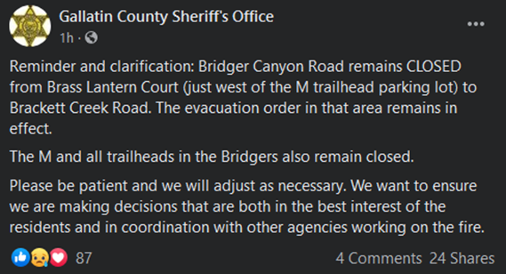
Responses
One of the first responses by the authorities was to issue evacuation orders and warnings for the residents of Bridger Canyon. Our family members currently at the house did all they could in haste to gather up as many irreplacible family items as they could, grab their essential belongings and get out. A few days later, residents were allowed back in first to check on properties and livestock, and now slowly some areas are being reopened for people to return as the conditions mean it is safe to do so.
This official government UAV drone footage both surveys the extent of the area impacted by the fire (supplimented by infrared detection), but also films an airplane make it’s fire retardant drop. What incredible skill needed by the pilot! But also, much appreciation should also go to all those involved in the planning and logistics of such operations.
It is worth noting here, that flying personal unsanctioned drones or UAVs during firefighting operations is a massive no-no. The authorities have repeatedly warned that doing so means that air operations to fight the fire must be grounded for the safety of the air crew. When you see how low that plane gets to the ground in the video above, they need no distractions what so ever.
Responding to a fire is a multi-agency effort. This fire had around 150 firefighting personel in attendance, including those from Bridger Canyon Fire Department. You have the Gallatin County Sheriff’s Office and the United States Dept. of Agriculture’s Forest Service amongst others working together to ensure the safety of residents and coordinate responses.
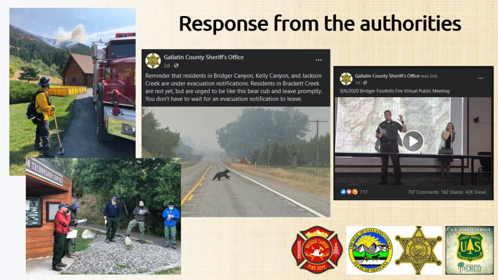
Another key agency involved is the National Interagency Fire Centre (NIFC), which helps support logistics and fire fighting operations. On 8th September, the Gallatin County Sheriff’s Office reported that resources included a single engine air tanker (SEAT) 6 helicopters, 2 Interagency Hotshot (Type 1) hand crews, 8 Type 2 hand crews, 15 fire engines, 3 water tenders, and 3 bulldozers.
The community response has been inspiring and heartwarming. As soon as word got out that the fire was a threat to lives and property, a Facebook group “Bridger Foothills Fire — Info & Resources” was started, and in just a matter of hours it had grown to over 5000 members.
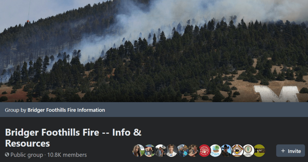
I joined the group initally out of anxiety to see if I could keep tabs on the fire and find out whether it threatened the part of Bridger Canyon where the family house is. But I found myself engaging in messages of encourgement, celebrating good deeds and joining in giving supportive reactions, messages or advice. I so desire to be out there to lend a hand physically, but while entities like Facebook have its critics, there is no doubt that it excels in facilitating bonding, connection and organisation when it comes to events like this. I could do my bit for the community despite being unable to be there in person.
Here are some highlights from the group, shared with permission.
Kathleen Smith was one of the group’s members quick to organise the checking and, if necessary, rescue of livestock and horses. When the authorities opened up windows of time to go into the area, she and others went in with trailers, or even just their trucks to move the animals to safety. The group was full of offers to house them, too.
Kathleen’s footage also made it into this news bulletin that gives more detail on the community rescue efforts for the horses and livestock.
There were many messages about donations, housing and supplies. The example here shows Alex Wilson, who worked with a team of people to organise pallet-loads of donations that came through the Salvation Army (below, left). What I was also heartened to see, was the messages of advice and support regarding the nitty-gritty, like recovery, insurance and mental health. One example is from Jen Giuttari (below, right) where she gave detailed personal non-legal advice based on her experience and expertise about insurance. In particular what caught my eye was advice #8, where Jen ensured the reader acknowledge and understood the mental toil, and the self-care needed, when going through the process of legal and insurance issues. This wasn’t the only post about mental health, and it was brilliant to see the community be so supportive and on the front-foot about it.
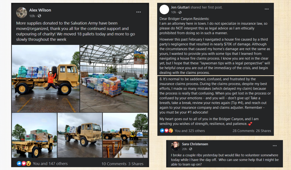
Indicative of the community support was a post by Sara Christensen, who desired to help out depsite having recently broken two ribs! People’s sense of humour is live and kicking on the group, too. Humour is known to be an important coping mechnism and morale booster in times of tragedy. There was a lot of praise and homage paid to the legend that is the Bridger Canyon Whale, which has the power to either curse or bless your time on the ski slope, as well as be a guardian angel for the area.
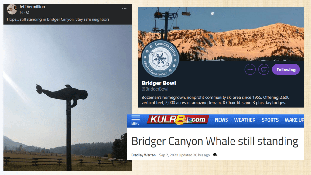
Many were ‘anxious’ to know if the whale was still standing. And it is. On a more serious note, the bit of fun linking the whale to skiing is to do with the Bridger Bowl ski area. There was a lot of concern that as the fire was spreading northwards along the eastern side of the Bridger range, that it could consume the complex. The Bridger Bowl is a non-profit community-led ski area that helps to bring in tourist money to the local economy. So news that the fire had, so far, not impacted it was very welcome. While the whale still stands…!
The latest
This video, published on the Custer Gallatin National Forest Facebook page, is the latest update prior to me publishing this blog post (10th September, around 2pm MDT). Rob Powell is Operations Section Chief for the Rocky Mountain Type 1 IMT. The key message is that crews have done a brilliant job in getting the fire contained – many of those ‘red borders’ I mentioned on earlier on the map, and now being coloured black.
Fundraisers & How you can help
Efforts are already underway to raise funds for those who are impacted by the fire. Given that I am in the UK, and my readers are from all over the world, I found out how ‘we’ in particular could help out if we so desired.
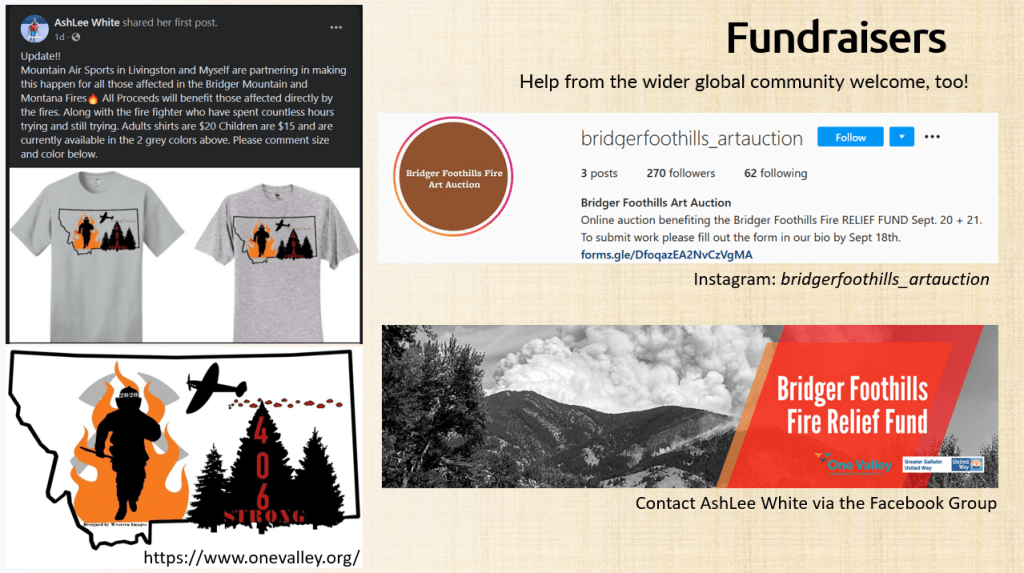
- Bridger Foothills Fire Art Auction: Takes place on 20th and 21st September. Organiser Chloe Nostrant welcomes bids from afar, on the presumption that the winning bidder covers the cost of shipping. Take a look at the amazing artwork being offered and contact Chloe for more info via Instagram.
- Custom ‘406 strong’ firefighting t-shirts: $20 for adults, $15 for children. Happy to ship out-of-state if postage is covered by buyer. Contact AshLee White via Facebook. (By the way, ‘406’ is the area code for all the phone numbers in Montana. It’s a huge state, but so sparsely populated that it only needs one area code!)
- If you would like to donate directly to the Bridger Canyon Fire Department, which is partially funded by donations, at the moment they can only accept cheques (spelt ‘checks’ in the US) from residents in the States with US bank accounts. If you are in the US and would like to donate to them, please name your check ‘Bridger Canyon Fire Department’ and mail it to the station at: 8081 Bridger Canyon Road, Bozeman, Montana 59715.
- Photographer Matt Jackson is having a sale of all the photos he has taken of the Bridger mountains, donating 100% of profits to relief funds. Check out his stunning work over at MT Darkstar Photography, and click on the Relief Sale banner.
- Anyone who would like to make a general financial donation to a relief fund. Visit the One Valley website, scroll down to read more about the Bridger Foothills Fire Relief Fund and click on the banner.
Climate Change: Getting closer to home for all of us
I wanted to end this article with the fundraisers above, therefore I have moved this bit into a follow-up blog post. I will look into how climate change is increasing the meteorological conditions needed for wildfires in Montana to occur, and how the impacts of climate change are getting closer to home for all of us. Click here to read on: “The Bridger Foothills Fire: The Shifting Bell-Curve”.
References, links & Further reading
Timestamps given for information used in the video:
- 5:30 – NIDIS US Drought Portal (https://www.drought.gov)
- 8:30 – Mikeal Béland’s Twitter thread about the outbreak of the fire (https://twitter.com/mikealbeland/stat…)
- 9:20 – National Interagency Fire Centre (NIFC) OPS Topo Map for 7th Sept 0400hrs (accessed via https://ftp.nifc.gov/public/incident_…)
- 10:02 – “Bridger Foothills Fire Perimeter 7 Sept. 2020”, Rob Maher (https://www.youtube.com/watch?v=1BliO…)
- 15:00 – More drone footage of the area in my blog post about the educational use of drones (https://geogramblings.com/2018/07/28/…)
- 18:00 – National Interagency Fire Centre (NIFC) UAS footage taken 7th September (accessed via https://ftp.nifc.gov/public/incident_…)
- 21:15 – InciWeb incident page and GIS map for the Bridger Foothills Fire (https://inciweb.nwcg.gov/incident/7144, accessed 8th September 2020)
- 21:50 – Paul Osincup’s Twitter thread (https://twitter.com/paulosincup/statu…)
- 26:05 – Bridger Foothills Fire — Info & Resources Facebook Group – although this is publically accessible, please respect its function as a community support group (https://www.facebook.com/groups/bridg…)
- 29:50 – “Bridger Canyon Whale still standing”, KULR8.com (https://www.kulr8.com/regional/bridge…)
- 34:32 – Bridger Foothills Fire Art Auction fundraiser (https://www.instagram.com/bridgerfoot…)
- 35:00 – Custom t-shirts fundraiser (contact AshLee White via https://www.facebook.com/groups/bridg…)
- 35:34 – Bridger Foothills Fire Relief Fund, One Valley and Greater Gallatin United Way (https://www.onevalley.org)
- 35:52 – 2017 Montana Climate Assessment (https://montanaclimate.org)
- 36:10 – Whitlock C, Cross W, Maxwell B, Silverman N, Wade AA. 2017. 2017 Montana Climate Assessment. Bozeman and Missoula MT: Montana State University and University of Montana, Montana Institute on Ecosystems. 318 p. doi:10.15788/m2ww8w.
- 38:23 – GA Magazine (https://www.geography.org.uk/Journals…, article cited will be in the Autumn 2020 issue)
All my education work via the Geogramblings’ “Life Geographic” blog is done all in my spare time, at my own cost but is free for you to access and enjoy. Usually here I mention how you can support my work; on this occasion, please instead consider contributing in some way to fundraising efforts to help those impacted by the Bridger Foothills Fire. Thank you! ❤️

2 thoughts on “Bridger Foothills Fire [Video]”