Examples of climate and energy data visualisations and how they can be used in the classroom

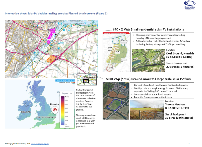
An article written for the World Energy and Meteorology Council (WEMC). It is becoming increasingly common place that education departments of governments around the world are including climate change in statutory policy. One such example is the recently released Sustainability and climate change: a strategy for the education and children’s services systems by the UK … Continue reading Examples of climate and energy data visualisations and how they can be used in the classroom

Advertisement

GAConf22 Coffee & Geography Special!

A few days ago I attended, in person, my first Geographical Association Annual Conference since 2019. The same was true of all other geography educators, since the last two had been totally online. This conference is for geography teachers, academics, exhibitors and students. It is always a wonderful event. Now that I have a podcast, I took the opportunity of grabbing my mobile recording equipment and doing a bit of recording for you all! Enjoy the listen.

European award for Climate Change GIS! (and other teachable goodies)

Find out whether a GIS for schools using climate data which I helped develop won an award from Copernicus ECMWF. But also check out the other amazing nominations that a teachers could use in the classroom.

Teaching climate change issues using GIS

The importance of teaching GIS and climate change and how the two together can provide a powerful way for students to learn about one of the most pressing issues of our time. I also put forward the argument that climate change is a safeguarding issue. What do you think?

Virtual tours (with Digimap for Schools)

🆕🌍🗣️ Virtual trips with Digimap For Schools - Ideas how to use the GIS tool for different kinds of virtual trips, including DMEs and links to 'real-world play'. Downloadable resources too! Featuring Geograph.org.uk

Mapping a walk (with Digimap For Schools)

🆕📽️🌍🗣️ Video blog! Mapping a walk with Digimap For Schools - How to use this amazing GIS tool, currently free during coronavirus lockdown, for building lots of skills relevant to primary school syllabuses & beyond. Great ideas for home schooling too. This blog also features Helen Young (Geography Geek), Norfolk Trials and Ordnance Survey.

‘GIS some more (GAeConf20 Part 3)

The final day of #GAeConf20 caused my mind to blow on several ocassions. Corn-starch glaciers, twisty graphs, and more challenge from a radical geographer. It's been quite a ride. Thank you, Geographical Association! #geographyteacher

Kicking it off online (GAeConf20 Part 1)

Today saw the kick-off of the Geographical Association's eConference 2020 - While all of us geographers are unable to gather together this time around - we certainly did in virtual spirit. Here's my quick review and thoughts of a successful first day.

Fake News? Think Critically…

Without delving too much into politics, it is of this geographer's opinion that current affairs demonstrate how crucial the current need is for critical thinking. This blog entry looks into the importance of thinking critically, a tool to help fight 'fake news', and some resources to demonstrate that teaching skills (like critical thinking) can happen in tandem with teaching content.

Your thoughts: Interactive climate & energy visual tool

A 'mini' placement has me looking into a useful climate and energy visualisation tool. Calling for feedback on making it a potentially effective educational resource! Featuring: @WEMCouncil, @CopernicusECMWF